Towsafe GeofencingUpdated 10 months ago
Electric towing devices like the Boogie are a new technology that allow foilers to explore uncrowded coastlines and catch many waves that traditional surfers cannot. A common concern is how to integrate them safely with other water users and swimmers, especially at popular surf beaches. Part of the solution for this is geofencing.
Geofencing, widely used by aerial drone companies, enhances safety and security by restricting access to sensitive or restricted areas such as airports, government buildings, and critical infrastructure. It helps manage airspace more effectively, reduces collision risks, and ensures compliance with local regulations, fostering responsible and safe usage. This same concept can be applied to the Boogie to ensure safe and responsible operation in the water.
Boogie modes of operation:
- Towing the user: The user controls steering by carving left and right and manages speed via a remote control. If they stop or fall off, the device stops immediately. While being towed, the user maintains high awareness of their surroundings and other water users due to their elevated position and the absence of noise or wake. This mode is very similar to an efoil.
Following or returning to the user guided by GPS: When the user catches a wave and releases the tow rope, the Boogie can automatically follow the user, provided they apply throttle. This mode depends on the user's common sense and responsibility to not use around other water users.
Geofencing Zones:
To enhance safety, especially in following modes, geofencing will be introduced. Geofencing will limit the device's operational speed based on location, with three distinct levels of restriction: Red, Orange, and Green.
Red Zone
- Restricted use with a maximum speed of 5 knots.
- Sufficient power to pull someone to safety but not tow on a foil.
- Includes areas like Sydney Harbour, very popular water use areas, or restricted zones such as the Byron Bay Marine Reserve.
- For practical purposes, the Boogie will not operate as a towing device in these locations.
Orange Zone
- Restricted use of Following and Summon features, with a maximum speed of 5 knots.
- Enabled at popular beaches and point breaks where surfers and swimmers are usually present.
- Strava heat maps are used to identify popular surf and swimming beaches.
Green Zone
- Unrestricted use of all available functions.
- Users must follow standard safety guidelines in line with PWC legislation.
- Enabled in less popular water use areas.
Calculation of Geofence Areas:
Many water users use smartwatches to record their activities and upload them to services like Strava. Strava creates global heat maps that highlight areas with high activity. By scanning the coastline, geofencing can be strategically implemented in regions of intense use. For instance, the snapshot from Broulee in NSW illustrates the concentration of surfers at various beaches along the coast. Geofence restrictions would be applied in these specific locations to ensure appropriate device usage. The interactive geofence map can be viewed here.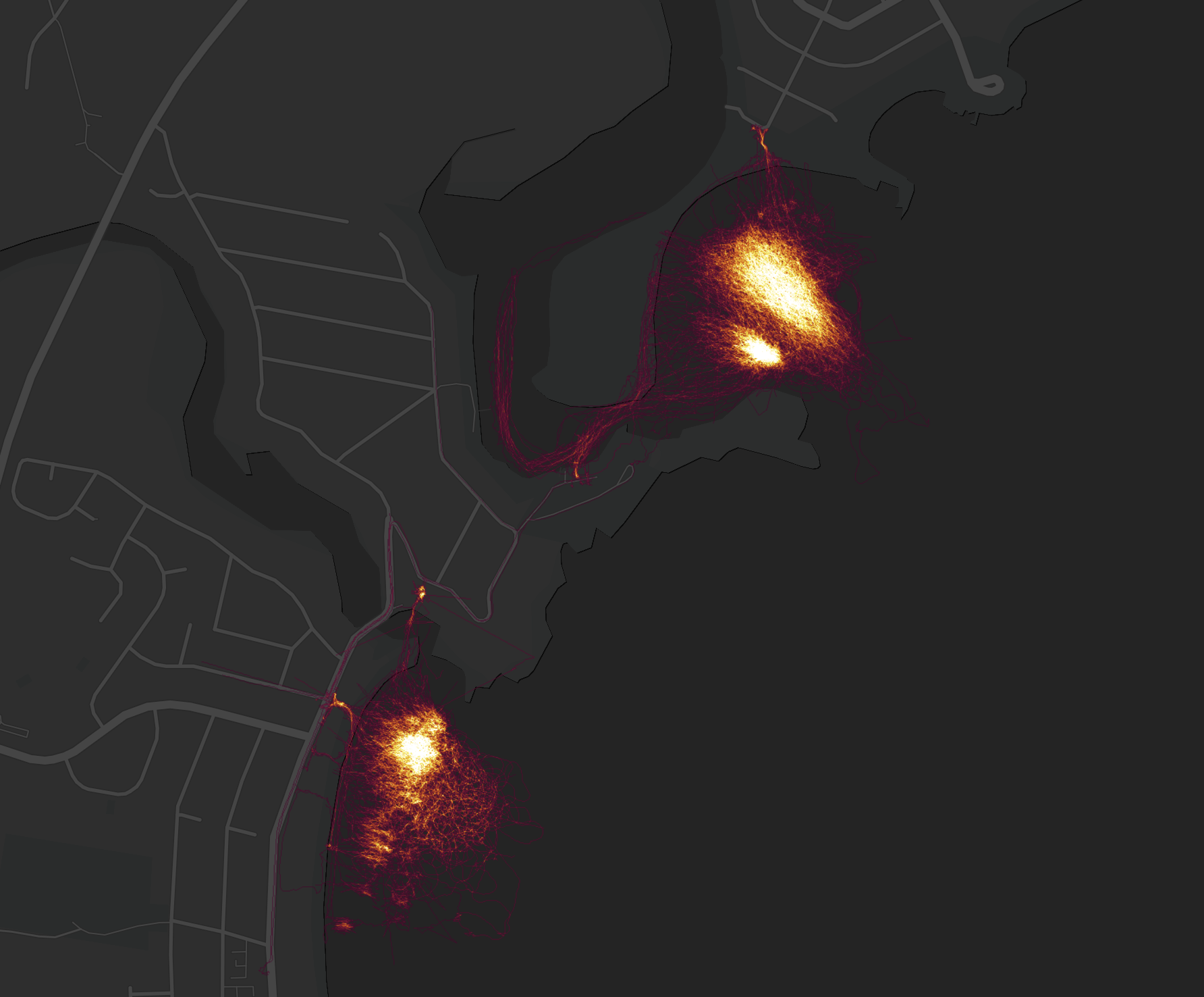
Uploading of User Logs:
To reinforce accountability, users must connect to the internet routinely to upload track logs and download the latest geofence data. These logs will be displayed as a heat map. Failure to connect to the internet will result in the Boogie defaulting to orange level restrictions, limiting the following and summon speeds.
The logs can also be used to identify areas of high towing use, helping to further refine the geofencing locations.